Cycling Maria Island

The weather forecast said “storm” but luckily down here in Tasmania the weather doesn’t read the weather forecast and does its own thing. The result was that we were on our way to hide up a long inlet when we noticed that things weren’t as bad as they were meant to be. Ten minutes later the inlet had been replaced with Chinamans Bay off Maria Island. We arrived just as the rain began.

05:45 Alarm clock goes off. Quick weather check. Blue skies.

Breakfast. Get the dinghy in the water and the engine on. Dress for cycling. Get the bikes out of the boat and in to the dinghy. Cross to the island and find a landing place. Build the bikes together.

08:10 on the bikes and off exploring Maria Island.

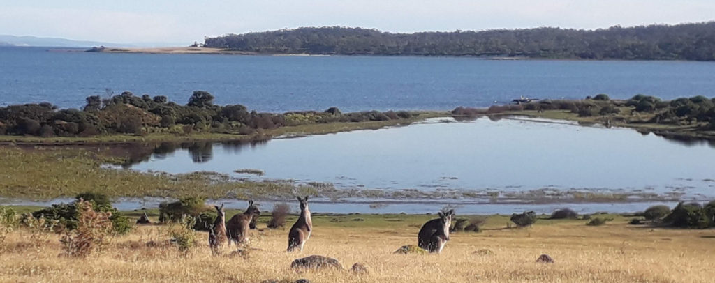
The island is uninhabited except for two park rangers who stay in “the city” at Darlington and the first ferry arrives just before nine so, to begin with, it was just us two and the kangaroos and the wallabies and the pademelons and the geese and the penguins and two extremely relaxed wombats. We cycled between the hundreds of “locals” who were all obviously confused about how we were there so early.

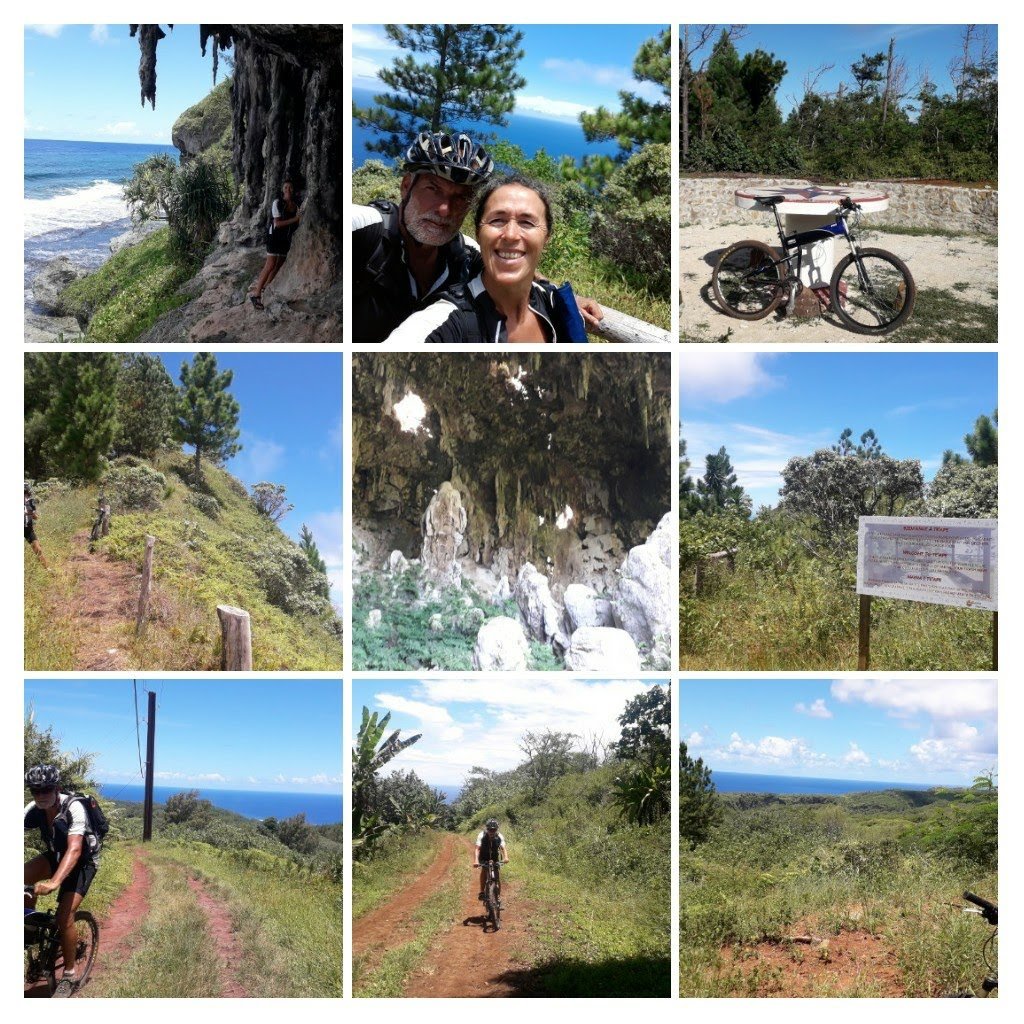
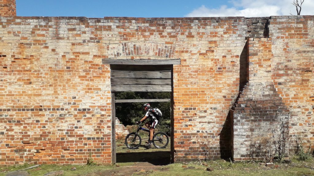
We passed ruins dating from the time when the island was used as a convict island and then took the “main road” through the forest to Darlington. The dirt track was well graded, gently rolling and completely devoid of motorized vehicles so perfect for mountain bikes.

In Darlington we found the “town” that was originally built as a penal settlement and later used as an industrial town. At the information office we asked about obtaining a park pass. The lady was a little surprised as you have to show your pass to get on the ferry. Theoretically you can not reach the island without a pass. We explained that we had sneaked in the previous evening and landed at dawn unseen by any one but the local wildlife at which point she thanked us for our honesty. It didn’t help though. The lady had no passes, the phone number she gave us only has an answering machine and the website won’t process us.

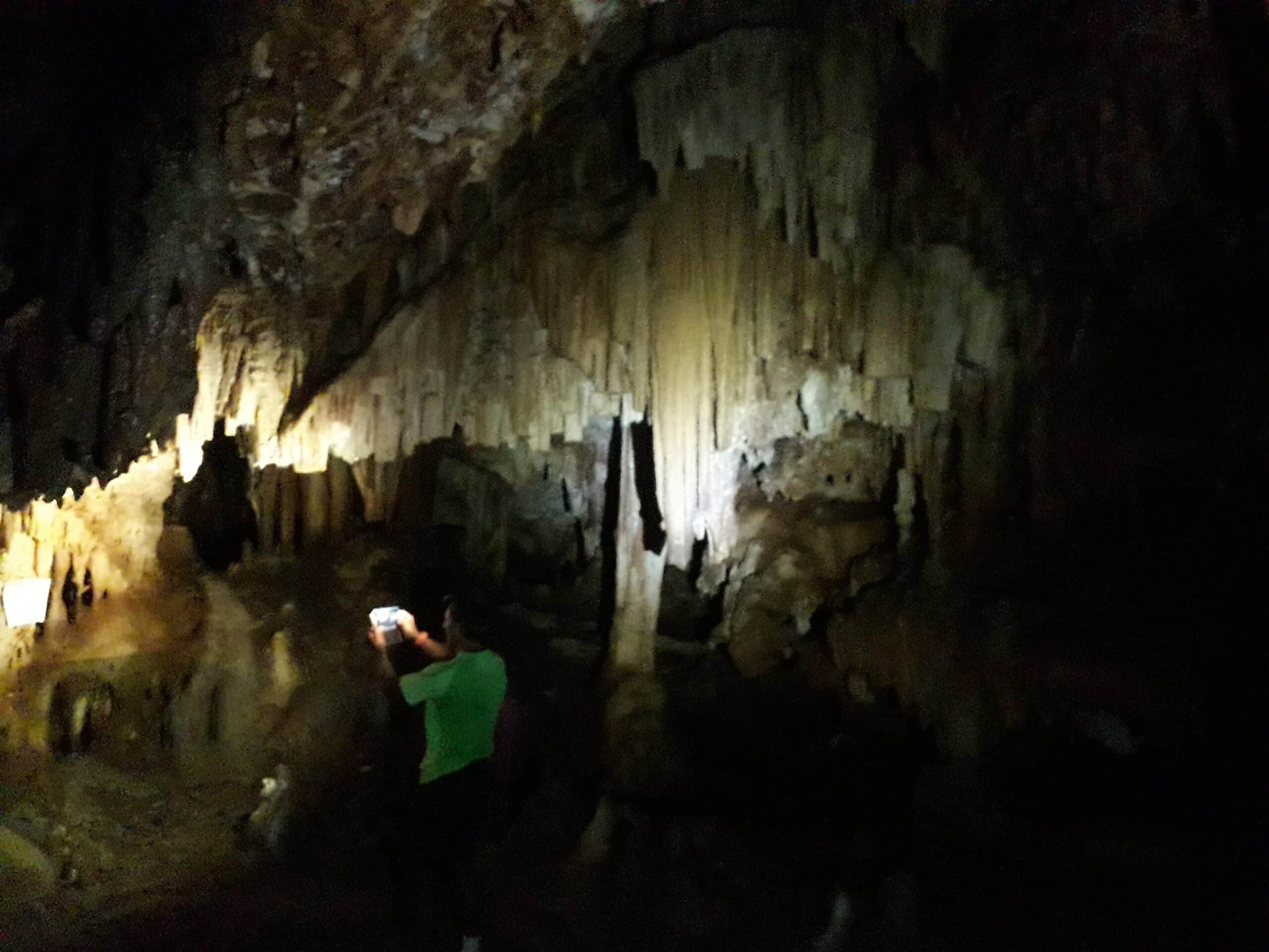
We had been advised to visit the old lime hoppers and sing in them which we did and thoroughly enjoyed the amazing acoustics as our voices reverberated around us. I admit that this was not an activity we would have thought of ourselves.

our “lime hopper” concert

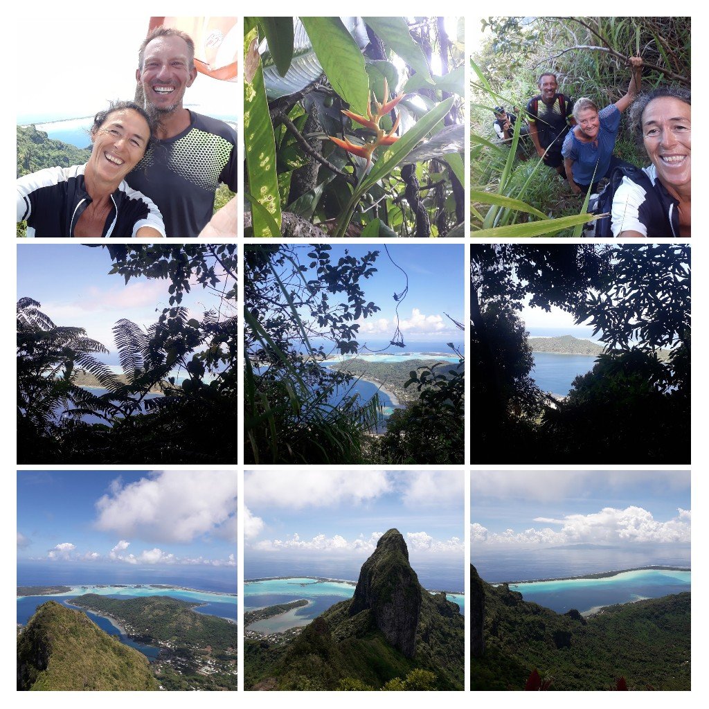
Leaving the town we cycled up a steep grassy hill (Heidi cycled – Neill cycled half way and then pushed.) At the top of the hill we were rewarded with a fantastic view back across the sea we had crossed the previous day with Mount Amos on the horizon. We took pictures and then continued back in to the forest and up to the islands reservoir. Back in town we visited the museum and were amazed to find an Irish visitor sat playing the perfectly tuned piano. What a treat.

Irish lady on a Tasmanian island

We headed back in to the bush and stopped off at an abandoned brewery / winery for our picnic. There is so much to see on this island but the clouds were already appearing to remind us that we were on borrowed time this outing and we should be getting on.

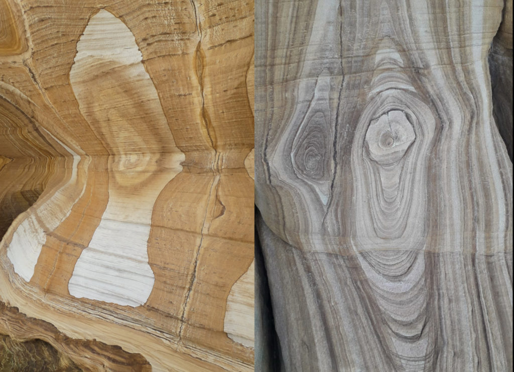
On our way back to the boat we stopped off at the painted cliffs. These are amazing and no photo can not do justice to the colors and textures of these rocks. You could almost believe that the aboriginal great father of all spirits had been painting here back in the dreamtime.

Back at the dinghy we reversed the morning activities and, before the winds arrived were packed and showered with a coffee in the cockpit. Being situative is half the secret to being lucky.

Sydney Harbour (and surroundings)

For over thirty years I had a dream to sail the world and that dream also included the moment when the boat finally sailed under the Sydney Harbour Bridge. For a European sailor, this is the proof that you made it to the other side of the world. Here is the moment that Artemis sailed past the Opera House to pass under the Bridge. Magical!

Artemis looks tiny

We anchored in a hidden bay beyond the bridge and made new friends when Wendy and Dave invited us for dinner and we returned the favour on Christmas Eve.

Catherine (our host in the Blue Mountains) came on board on Boxing Day and as soon as she was onboard we lifted anchor and set off to witness the start of this years Sydney to Hobart race. There were thousands of boats spectating the chaos at the start of the race but we managed to work our way to the edge of the exclusion zone and enjoy watching crazy people doing crazy things.

111 vessels racing and 1000 spectator boats

The next day we anchored off Cockatoo Island – an ex prison and then shipyard – and took the dinghy to the interesting place. The visit confirmed what we already knew from other prisons – the convicts were sent to Australia as slaves. The new colonies needed free labour and the criminals supplied that manpower in awful conditions.

She definitely is

From Cockatoo Island we sailed through Sydney and out to the seaside town of Manly. The wind was against us so we needed to tack regularly, but with two farmers daughters as crew it was easy. The ferries very professionally avoid sailing vessels but the two cruise ships we met are just too big to avoid anything. We went round them.

We’re on the top of the world … (thank you Muhammad Fawad Faheem for the photo)

In Manly we climbed to the top of a neighbouring hill to enjoy the view out to sea and back towards Sydney. On our way we passed a packed beach full of Australians enjoying summer and noticed a lot of people were regrettably transitioning from pure white to lobster red. Surely they can’t all have Scottish ancestry.

Back in Sydney we sailed in to the heart of the city and, after visiting the fish market, picked up Heidi – our second visitor. Having two Heidis onboard was a challenge. One was navigating and one was on the helm steering us among the ferries. My commands were on the lines of
“Nav-Heidi, where is the next turn point?”
“At the end of the Island.”
“Helm-Heidi, turn towards the water tower after the next ferry passes.”

We anchored in Farm Cove, right next to the Opera House, on the thirtieth to wait for the New Year fireworks. On the thirty-first the bay began to fill with boats and people started covering the surrounding coastline. I was wondering what could be so good that people were willing to sit for over eight hours to reserve a place. We had our home with us and could enjoy all the comforts but they were sat on a blanket just waiting with an ice box and Portaloos.

On the shore behind us there was a private party area where people had paid AUD 475 (€300) each to enjoy a three course meal and the best view of the fireworks. We ate a four course meal, drank champagne at midnight and sat on Artemis right in front of them so that our mast was in their way 🙂

The fireworks were phenomenal. They were breathtaking. They were loud. They were bright. They were indescribable. I now know why people sit on their blankets all that time. Wow!

In to the Blue Mountains

Heidi checked the Internet for “what to see in Sydney” and the answer was always:
– Blue Mountains,
– Harbour Bridge,
– Opera House.

The Blue Mountains were only a hundred kilometers from Pittwater where we were at anchor and we knew Catherine who lived “in the mountains”. It turned out that Catherine was on holiday in California and ten marinas had no space for the boat so things were not looking too positive. But, as so often, it all turened out OK in the end. Catherine flew home and one marina had one buoy for one week.

We left Artemis attached to her buoy and set off along the windy road through the hills of the Ku-ring-gai Chase National Park. Of course the first kilometers were all uphill. Once we left the forest we entered Suburbia and stayed there for the rest of the day. Sydney sprawls out across all the surrounding plains and hills which gave us a great chance to see “how the locals live, shop and amuse themselves”. After seventy kilometers we stopped in Windsor for the night and enjoyed a well earned pizza and wander along the high street where we found a tree full of the loudest parrots you ever heard.

On Day two we could see the mountains in the distance and after only twenty kilometers we reached the serious climb from the river up to the Hawkesbury Lookout. After that is was all uphill to Faulconbridge and Catherine’s lovely home. We were given a bed, fed, met the dogs, enjoyed Catherine’s company and had the use of the hot tub. What more could we ask for.

Directly from the house door, we rode out along a fire trail to the Grose River Lookout. This is a bit surreal as you leave the town behind you and ride through the surrounding forest until suddenly the track stops on top of a huge cliff. Imagine the Grand Canyon with trees. It is definitely not something we were expecting “on the edge of town”.

Our next trip started some way from Faulconbridge so we cycled across to the Railway station to catch a train. Unfortunately that night there had been a serious derailment so the track was closed. Once again Catherine saved us by lending us her car. From Blackheath we cycled out to the Baltzer Lookout. Same sort of effect as the previous day except that we were above a thousand meters so the cliffs are higher and there is a huge section of cliff called the Hanging Rock which is nearly detached from the mountain and looks ready to fall off.

On the fifth day we left the bikes on the porch and enjoyed a guided tour of the Mountains led by Catherine. More stunning views, a tasty lunch in a quirky little restaurant, the hundred meter high Wentworth Falls, more views and then afternoon coffee and cake in a hotel left over from the last century. It was almost as exhausting as the seventy kilometers on Day one.

We left the mountains by cycling up the motorway! It was an Australian motorways so it had a footpath and a bike lane which we made use of. After a few kilometers we turned off in to the bush and enjoyed the stunning Woodford Oaks Fire Trail. This is a track that runs generally downwards along one of the ridges in the bush. It has great biking, great views and lots of nature. A real “Wow”.

We added in a ten kilometer diversion to visit the red hands cave. This is an amazing site where hands have been painted on the back wall of the cave by aborigines. Some of the hands were painted 1600 years ago at the same time as the Romans were still occupying Britain. That takes some time to get in to your brain.

Finally, at the foot of the mountains, after a final seven kilometers of rocky single trail, we took the train to Sydney. Now we know why the Blue Mountains are at the top of the “things to do” list. Stunning is the only word.

The tracks are here:
Day 1 to Windsor
Day 2 to Faulconbridge
Grose River Lookout
Baltzer Lookout
Woodford Oaks Fire Trail and Red Hands Trail

Pittwater

Pittwater is a huge harbour just to the north of Sydney and is where half the population of Sydney keep their yachts on mooring buoys. We sailed overnight from Port Macquarie to the entrance and waited offshore until first light when we entered passed the lighthouse, ghosted along pushed by the breeze and dropped the anchor in Morning Bay.

We were anchored in a national park so we took the dinghy to shore and headed for the hills following small trails through the bush. We were rewarded by stunning views across the boat filled waters. On the way back down we took a wrong turning and were punished by a bull ant attack. Strangely for Australian animals, the ants are not really poisonous; the sting just burns like hell. Not an experience we wish to repeat.

The next day we were visited by Paul on his sailing boat and invited round to “their” bay at Coaster’s Retreat. (We know Lucie and him from Bundaberg.) They organised us a friend’s mooring buoy and made us extremely welcome. Their hospitality knew no end and included showers, drinks, dinner, the garden wallaby, sailing on their ketch and a guided walk through the surrounding hills. They definitely get five stars if they are ever listed on Trip Advisor.

During the week, Pittwater is a beautiful area to sail but unfortunately, at the weekend, it is taken over by two types of idiots. Firstly there are the racers. They know who should give way to who but believe that being in a race allows them to do whatever they want. At least you can more or less rely on them cutting dangerously close to you. Secondly there are the common variety of idiot. It is impossible to discern if they just do not understand the laws of the seas or have a rudimentary knowledge but fail to apply it. Either way they are extremely dangerous. Taken together the weekends are a good time to stay at anchor and go for a walk.

Behind the Pittwater is the Ku-ring-gai Chase National Park which starts on the shore. Luckily the forest is penetrated by long flooded river valleys which you can sail up. We followed the Hawkesbury River and then turned in to Cowan Creek before taking the narrow Smiths Creek and spending the night in Squid Bay. Here we were deep, deep in the forest and surrounded by steep, forested sandstone cliffs. Unfortunately two other boats turned up for the night but it was still beautifully peaceful.

Back down the river and across the bay, we anchored off Palm Beach and walked along the busy street to the supermarket. Two locations, about ten kilometers apart, but two worlds.

Rurutu – ein Traum

30 Seemeilen bevor wir anlegten, sah ich zum ersten Mal die Insel. Bei soviel vorab Informationen war ich ziemlich aufgeregt 🙃😲 und konnte es fast nicht mehr erwarten,  endlich wieder Radler zu sein. Wir ankerten im Hafen, wo bereits mittendrin ein anderes Segelboot, das dem örtlichen Arzt gehört, lag ⛵. Nach dem wir unser Boot routinemäßig abgestellt hatten, waren wir einfach nur müde, wir gönnten uns ein leckeres Essen und ab ging es ins Bett😏. Am nächsten Morgen meldeten wir uns vorschriftsmäßig bei der Gendarmerie, inspizierten das Dorf und erkundigten uns wo wir Wasser, Internet, Diesel usw. bekommen. An der Post fanden wir eine Insel Karte mit den Straßen, Höhlen und anderen Sehenswürdigkeiten ; also jetzt nur noch die Räder zusammen bauen und los geht’s 🚲🚲. Aber zuerst wollten wir noch das Hafenbecken mit dem Dinghy vermessen, damit wir unseren Freunden Doris und Wolf von den Seenomaden mitteilen können, dass auch für Sie Platz zum ankern ist.

Am Sonntag den 31.1. Als wir morgens die Fahrräder an Land brachten, staunten wir nicht schlecht, als dort Terry, ein Franzose den wir schon aus Tubuai kannten, stand 😲. Er erzählte uns, dass er heute Nachmittag zurück nach Papeete fliegt und wenn wir wollen würde er uns noch eine Höhle zeigen 👍👍. Welche Frage?! 😊😁Gott sei Dank, denn alleine hätten wir diese sagenhafte Stalaktiten und Stalagmiten Höhle niemals gefunden.

Stalaktiten und Stalagmiten

Nach dieser Expedition trennten sich unsere Wege und wir radelten erst einmal um die Insel; nur so 36 km aber allerdings auch fast 800 Höhenmetern und über drei Pässe.

🙈🙈 Ganz abgesehen von den 30 ° Außentemperatur und ca. 70 % Luftfeuchtigkeit 😲😲 und den steilen Betonstraßen 🙃. Dass wir ab und zu mal schieben mussten war unvermeidlich, doch der Blick über die gesamte Insel entschädigte uns für die Strapazen. Von Tama, dem Zahnarzt in Tubuai, bekamen wir den Rat, unbedingt Rurutu zu Pferd zu erkunden 🤔🤔 warum eigentlich nicht, denn wir kennen nicht viele, die auf den Austral Inseln beim reiten waren.

Reiten in Rurutu

Wir fanden Elin, eine Waleserin die hier verheiratet ist und deren Ehemann Viriamu die Reitsafarie veranstaltet. Was soll ich euch sagen, es war einfach spektakulär wie die kleinen Pferde bei der Hitze die steilen Wege meisterten und wir hatten schon fast ein schlechtes Gewissen uns von Ihnen bis auf einen 300 Meter hohen Gipfel tragen zu lassen. Doch auf diesen zugewachsenen Trampelpfaden wäre ein Durchkommen für uns nicht möglich gewesen😜. Unser Guid stoppte sein Pferd, verschwand im Dschungel und kam mit Bananen und Passionsfrüchten zurück, die wir dann am Gipfel gemeinsam verspeist haben 👍.

Die nächsten zwei Wochen haben wir glaube ich alle fahrbaren Wege auf der ganzen Insel abgegrast 😅😅 und es waren absolut verschiedene Pfade, Untergründe, Ausblicke und Eindrücke. Wen es interessiert hier sind die Links zu unseren Tracks. Einmal der Blick vom höchsten Berg aufs Riff, dann die rote Erde wie in Afrika, dann Wurzeltrails mit Föhrenwaldwegen, steile Schotterabfahrten, Höhlen und Korallen Blöcke wie Steine im Garten verteilt. 😲😲😲

Rurutu

Ich kann nur für mich sagen, dass Rurutu eine der außergewöhnlichsten Austral Insel ist, nicht nur wegen der genialen Wege zum Radeln auch wegen der verschiedenen Möglichkeiten von Wandern, Höhlen erforschen und der unterschiedlichsten Anbau Möglichkeiten von Kaffee in Plantagen, Taro Feldern, Bananen, Noni Bäumen, Pampelmusen, Limetten, Granatapfel, Guaven, Avocados und vieles mehr. Nicht zu vergessen die fast freilaufenden Schweine, Hühner, Ziegen und sogar ein paar Kühe haben wir gesehen. 😜

Elin hat uns erklärt, dass hier auf dieser Insel alle Obstbäume und Palmen,  die am Straßenrand stehen für jeden zur Verfügung stehen und sich jeder daran bedienen kann. Wir haben Limetten, Kokosnüsse, Pampelmusen, Bananen und Guaven gefunden 👍. Als wir einen Bauern wegen Avocados gefragt haben, nahm er uns mit nach Hause und hat uns gleich 10 Stück Avocados und Taro gegeben; als wir nach dem Preis gefragt haben, lachte er und meinte es sei gratis. Wieder einmal waren wir überwältigt von soviel Großzügigkeit und uns blieb wieder nur ein herzliches Dankeschön zu sagen 🙏🙏🙏. Auf unserer Artemis angekommen haben wir einen Schokoladenkuchen gebacken und als kleinen Dank am nächsten Tag vorbei gebracht bzw. geradelt 😁😁 und unsere Geschenke haben wir mit Doris und Wolf geteilt. Ich glaube, dass ich noch nie soooo gute Avocados gegessen habe und die Ökobilanz ist auch großartig. Mit ein bisschen Wehmut verlassen wir Rurutu, doch wir sind froh und glücklich hierher gekommen zu sein 👍👍.

Hier könnt ihr sehen wo wir überall waren

GPS tracks:

Raivavae in den Austral Inseln

Die Austral Inseln – bis vor einem Jahr wusste ich überhaupt nicht, dass es diese Inseln gibt und jetzt waren wir auf dem Weg dahin 😊. Zwei uns bekannte Boote waren in Tubuai und wir wollten gemeinsam Weihnachten verbringen also stand das Ziel bereits fest, doch kurz bevor wir aus dem Pass von Raiatea fuhren riefen Sybille und Bo an und erzählten uns, dass die “Weihnachtszeit” auf Raivavae verbracht wird. Okay dann eben 100 Nautikel Miles weiter und gut, nach sechs Tagen hatten wir in Raivavae wieder Boden unter den Füßen und konnten uns bei der Gendarmerie melden. 👍Wir ankerten von der Stadt, denn von hier aus war es viel einfacher unsere Räder an Land zu bekommen und endlich mal wieder Radler zu sein 🤗🤗. Der Polizist erzählte uns, dass es auf der Insel eine Traverse zur anderen Seite gibt, die eine Steigung von 45 % hat 😲😲 und daß man das Fahrrad schieben sollte, denn ein Tourist ist wohl 2019 schwer verunglückt. Das wollten wir uns natürlich so schnell wie möglich anschauen.

Silvester

Mit Regenzeug im Rucksack, Plastikplane zum Schutz für unsere Räder bestiegen wir das Dinghy und haben es immerhin trocken an Land geschafft 😏 beim montieren wurden wir bereits das erste Mal nass. Außerdem hatten wir ein Publikum von Einheimischen, die ganz interessiert verfolgten, was aus unseren Taschen zum Vorschein kam. Dank unserer französisch Kenntnissen konnten wir uns sogar unterhalten 🙈🙈 und die Einheimischen meinten, dass die Traverse “tre difficil” sei; wir hatten leider das Pech, dass es total rutschig war und sogar beim schieben wussten wir oft nicht wie wir vorwärts kommen sollten 😜 doch auf der Passhöhe hatten wir einen genialen Blick zur anderen Seite. Wir staunten nicht schlecht, dass dort vor diesem Moto bereits 10 Boote lagen, doch bei türkisblauem Wasser, Sandstrand und einem geschützten Tümpel wollten wir natürlich auch dort hin. Ich glaube, dass wir alle Straßen um und über Raivavae abgefahren sind und als wir zurück zum Hafen kamen hat es wieder geregnet. Die örtliche Krankenschwester hat unseren Fahrrädern 🚲🚲 Asyl gewährt und so konnten wir sie dann sauber und trocken verpacken.

Am 21.12. konnten wir dann auf die andere Seite fahren, was aufgrund der vielen Korallen gar nicht einfach war doch Gott sei Dank sind wir ohne Kontakt angekommen.🙏🙏 Von hier aus haben wir dann auch den Mont Hiero mit seinen knapp 450 Metern, den höchsten Berg, erklommen. Beim Spaziergang wurden wir von Einheimischen zum Boules spielen und Bier trinken eingeladen und am nächsten Tag hat uns Eduard, einer der Einheimischen, Bananen, Papayas und Manjok geschenkt. Wir wollten ihn zu uns auf Boot einladen, doch er meinte dass er seekrank würde und so konnten wir uns nur mit selbstgemachten Bananenbrot revanchieren.

Weihnachten haben wir mit Sybille und Bo gefeiert und an Silvester durften wir Segler ein Lagerfeuer am Strand machen; jeder brachte was zum Essen und Trinken mit und so hatten wir ein gemischtes Buffet mit viel sprachiger Konversation. Ganz traurig hab ich an alle daheim gedacht, die dieses Jahr nicht feiern durften 😪😪 aber 2021 wird bestimmt alles wieder besser 👍👍

GPS tracks

Tubuai

Ganz entgegen gesetzt der normalen Reiserichtung sind wir am Samstag 9.1. in Tubuai angekommen und genau wie uns alle erzählt haben ist die Lagune sehr “bewegt”, was bedeutet dass hier viel Swell ist und nichts von einem ruhigen Ankerfeld zu spüren ist.😜 Weil Neill Zahnschmerzen hatte☹️ und weil uns der örtlichen Zahnarzt, Dr. Tama sehr empfohlen wurde, haben wir uns gleich am Montag in seine Praxis begeben. Neill wurde bestens behandelt👍 und Dr. Tama hat uns zu sich und seiner Familie, die aus seiner Frau Mila und seinen fünf Kindern besteht, eingeladen. Wir wurden dort so herzlich empfangen und ich hatte das Gefühl, als ob wir uns schon seit Jahren kennen. Mila hat mir eine wunderschöne Blumen Krone gemacht und außerdem noch Tanzunterricht in heimischen Stil gegeben. 👍 Bevor es dunkel wurde machten wir uns auf den Rückweg und verabredeten uns für den nächsten Tag bei uns auf dem Boot.⛵⛵

Wir fragten bei der Hafenmeisterei an, ob wir unsere Artemis an den Kai anlegen können, um unseren Gästen den Besuch etwas zu erleichtern ☺️. Adrian, der Verantwortliche meinte, dass es kein Problem sei und so konnten wir unseren Besuch viel einfacher an Bord nehmen. Wir haben Schokoladenkuchen und Pizza gemacht und die Kids waren völlig damit beschäftigt, das Boot zu erkunden. Neill hat den Jungs das Dinghy fahren gezeigt und danach wurde im Wasser herum geblödelt. Viel zu schnell verging der Nachmittag 😊😊und Mila bot uns an, als Reiseführerin mit uns den höchsten Punkt der Insel zu besteigen. Was soll ich euch sagen, wir haben so viel über Flora, Fauna, Geschichte und Sagen von Tubuai erfahren 😲😲😲und ich brauch nicht zu erwähnen, dass Mila ihre Insel liebt und alles was damit verbunden ist. Unterwegs haben wir Narii, Milas Cousin, mit französischen Gästen getroffen und die haben sich dann am Freitag noch unser Boot angeschaut 😊.

Als wir bei der Gendarmerie waren, kamen wir ins Gespräch über Tempelanlagen hier auf Tubuai und dass diese sehr schwer zu finden sind. Daraufhin hat der Gendarm uns angeboten, am Samstag weil es sein freier Tag ist, mit dem Fahrrad diese Anlagen zu besuchen. 😲😲😲 Ich bin total überwältigt von so viel Freundlichkeit, Hilfsbereitschaft und mit welcher Selbstverständlichkeit die Menschen hier uns “Fremden”, begegnen und es als total normal empfinden, uns alles zu erklären und zu zeigen. Heute Nachmittag als wir ins Dinghy gestiegen sind hat uns ein örtlicher Fischer einfach so drei Fische geschenkt und als wir uns mit dem Einheimischen “Maururu” bei ihm bedankt haben hat er gelacht und uns zugewinkt. 😚😚😚 Ich wünsche mir so sehr, dass uns etwas von diesem Verhalten anhaften bleibt und wir es über die ganze Welt verteilen🙏🙏🙏.

GPS tracks

Raiatea

Auf dem Weg nach Maupiti haben wir wohl eine unserer Wanten (das ist eines von den Drahtseilen, dass den Mast hält) gerissen und deshalb mussten wir hier in Raiatea einen Rigger aufsuchen um es reparieren zu lassen. Allein das Bestellen des Ersatzteiles entwickelte sich als ein “Projekt”, denn der einzige, der es anfertigen konnte war in Tahiti und der wollte irgendwie nicht so recht 😜. Also haben wir kurzer Hand wieder unsere Ocean Chandlery und den Rigger, der unsere Artemis am Anfang geriggt hat in UK angeschrieben, die Maße durchgeben und nach 10 Tagen konnte Fred (so heißt der örtliche Rigger) die kaputte Wante reparieren.

Um die Wartezeit zu verkürzen sind wir einmal um die Insel geradelt. Irgendwie sind wir gar nicht mehr daran gewöhnt, dass wir bedenken müssen, daß es einen ganzen Tag regnen könnte. Doch genau dass war die letzten beiden Tage der Fall, es regnet wie aus Eimern 🙈🙈(ich weiß ja auch, dass hier jetzt Regenzeit ist, aber trotzdem 😏🙄☹️) und beim radeln hatten wir riesiges Glück, dass es immer wieder aufgehört hat. Viermal mussten wir uns unterstellen um nicht patsch nass zu werden. Aber nach 95 km waren wir wieder ziemlich trocken zurück. Unsere Fahrrad taschen konnten wir in der Werft bei einem Segler deponieren 👍👍 Gott sei Dank, ansonsten hätten sie unser Dinghy als Swimmingpool benützen können 😲. Lange Rede kurzer Sinn nach drei Tagen haben wir es endlich geschafft unsere Räder trocken und sauber wieder an Bord zu bekommen. Jetzt geht es nochmal in die Stadt um unser Boot wieder mit Proviant aufzufüllen und dann hören wir die Austral Inseln schon rufen 😃😃. Den richtigen Wind abwarten und los 😃😃⛵.

GPS track – 20201206 round Raiatea

Taha’a

Zwei Inseln, die sich ein Riff teilen 😲wie interessant ; dann werden wir uns doch als erstes die Kleinere anschauen 😊. Wir haben uns ja schon ein bisschen schlau gemacht und wussten, dass es hier eine Straße entlang der Küste gibt, die ca 63 km lang ist und die fast die ganze Insel umspannt. Außerdem soll es hier eine Rum Destillerie geben, die nur lokale Rohstoffe verwendet und wo man auch eine Verkostung machen kann 👍👍. Wir machten uns auf Erkundungstour, fanden die Brennerei und versprachen, mit unseren Freunden wieder zu kommen. Am Straßenrand gab es Bananen zu kaufen und als wir der Frau in unserem “wahnsinnig gutem” Französisch erzählt hatten, dass wir auf dem Boot leben, hat sie uns gleich noch dreimal so viel Bananen und noch ein paar Mango gegeben 😁😁. Wir haben unsere Früchte mit Sybille und Bo geteilt und vom Rest wieder Chutney gemacht. Am 28.11. haben wir dann die Insel auf dem Rad erforscht. Irgendwie haben wir gerade keinen guten Draht zum Wetter Gott, denn dieses Mal wurden wir schon auf dem Weg vom Boot an Land nass 😲🙈. Aber dann hat es aufgehört und wir konnten die Radtour durch den “botanischen Garten” wie ich diese Insel nannte, in vollen Zügen genießen. Wirklich die Vielfalt an bunten Blumen, Hecken, Früchten und Gemüse ist wahnsinnig ; als wir ein Schild einer Vanille Plantage sahen haben wir angehalten, uns die Vanillepflanzen und – Blüten angeschaut und gefragt, ob wir welche kaufen können 😁aber die hatten als kleinste Menge nur 10 Vanilleschoten verpackt und dass war selbst zum teilen viel zu viel für uns.

Zum Abschluss haben wir dann noch die Rum Brennerei besichtigt und ganz klar auch den ein oder anderen Rum probiert 😆😆😜 ich kann euch sagen, dass hat ganz schön reingehaut bei 30 Grad, 80 % Luftfeuchtigkeit und nach 65 km radeln 😲😲😜. Als wir unsere Räder wieder verstaut haben, haben uns amerikanische Touristen gefragt, wo denn hier die Stadt sei und wir meinten, ihr seid mittendrin 🤣🤣🤣 eine Tankstelle, ein kleiner Laden, eine Rum Brennerei was braucht man denn sonst noch? Mmmm 🤔🤔🤔vielleicht einen Fahrrad Laden, denn ich habe – keine Ahnung wie ich dass wieder angestellt habe – eine Speiche im Vorderrad abgebrochen 🙈🙈. Na ja hoffentlich findet sich auf Raiatea, das ist ja immerhin die zweit größte Insel in Französisch Polynesien, ein Radgeschäft, der so etwas reparieren kann 🙏🙏 und unser nächstes Ziel 😊.

GPS track – 20201126 round Taha’a

Bora Bora

Wenn ich bisher etwas von Bora Bora gehört habe dachte ich an eine Südsee Insel mit weißen Stränden aber bestimmt nicht an steile Berge 😊. Doch genau das war unser Ziel den Mont Pahia zu besteigen, denn schwimmen und schnorcheln können wir immer noch; als wir recherchiert haben fanden wir alle möglichen Aussagen von wahnsinnig gefährlich und ohne Guide nicht zu schaffen bis hin zu sehr guter Trainingszustand notwendig. Aber in allem waren sie sich einig: nur bei trockenem Wetter zu besteigen 😲. Zusammen mit Sybille und Bo gings los, der Aufstieg  war ziemlich schwierig zu finden  (wahrscheinlich auch ein Grund dafür, damit man einen Führer nehmen soll 🙈) . Es ging über Stock und Stein,  moosige Felsen und rutschige Bachläufe; der Weg führte uns durchs Unterholz mit vielen Spinnennetzen, Salamandern und sonstigen Krabbeltieren 😜 und ohne dass wir über Äste oder Felsbrocken klettern mussten, kamen wir nicht voran 😲. Glücklicherweise waren sehr häufig Seile gespannt um uns Sicherheit zu vermitteln und uns etwas Halt zu geben. Nach dem ersten steilen Anstieg, führte ein Rundweg auf die Rückseite des Berges und kurz vor dem Gipfel durften wir noch ein bisschen kraxeln 🤣🤣dafür wurden wir mit einem traumhaften Blick vom Mont Ohue belohnt. Für Sybille als “Flachländerin” war es Kletterpartie genug und wir wussten, dass das letzte Stück nochmal eine Herausforderung für Nicht Kletterer bereit hält. Deshalb machte Bo und ich uns fertig für den Katzensprung zum Mont Pahia; Sybille und Neill warteten auf uns. Wir mussten wirklich ein Stück überhängend klettern  😲😲 und das war nur wirklich etwas für schwindelfreie Bergsteiger 👍 aber dafür war die Aussicht einfach WOW! 😆.

Bergsteigen auf Bora Bora

Nach einer ausgiebigen Brotzeit mit frischen Baguettes, Wurst und Käse brachen wir zum Abstieg auf; keine Sekunde zu früh wie sich später heraus stellte. Die feuchten, rutschigen Stellen waren super abgetrocknet und wir kamen zügig voran. Irgendwann meinte Sybille “ich hoffe, dass es bald mal so richtig regnet, damit das ganze Salz vom Boot abgewaschen wird und alles nicht mehr so klebt”.                                   Scheinbar hat sie gute Konektion, denn kurz darauf hat es angefangen zu regnen und zwar ausgiebig, doch wir waren fast schon wieder im Dorf und konnten die kostenlose Dusche gleich als Vorwäsche nutzen 🤣🤣. Wie die getauften Mäuse saßen wir im Dinghy und ob ihr es glaubt oder nicht es war richtig kalt im Fahrtwind 😨, doch dafür war das Meerwasser Badewanne Temperatur 👍👍. Zur Feier haben wir uns einen oder zwei Cocktails im Bora Bora Yachtclub gegönnt und für den nächsten Tag eine Radtour um die Insel ausgemacht.

Aperol Spritz 😉

Doch die 32 Kilometer und 400 Höhenmeter haben wir dann wirklich mit links gemacht. Jetzt wird noch ein bisschen hier geschnorchelt und dann eine andere Insel in Angriff genommen 😊😊.

Blick über Bora Bora

GPS tracks: Our climb. Our route round the island.