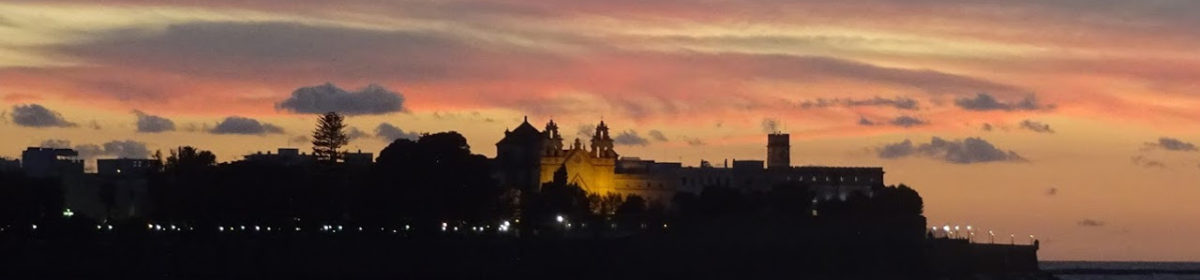
Who hasn’t dreamed of an uninhabited coral atoll in the middle of the Pacific? A ring of living coral and waving palm trees encircling a transparent blue lagoon. And floating gently at anchor a tiny sailing boat, alone under the blue blue sky.
Here we are. At Tahenea living the dream. Artemis is anchored in her own bay far from the rest of the world. The reef keeps the breakers at bay and the minimal wind leaves the surface mirror flat so that we can glance at the “aquarium” we are floating on. We look down and see fish floating past the coral boms below us.
The passes through the reef. (photo by seenomaden.at)
In the night the full moon is so bright that we can still see the sea floor fifteen meters below us.
At sunrise there was no wind so we breakfasted in the cockpit on fresh, home made bread while enjoying the absolute stillness here in the middle of the Pacific Ocean.
Today friends sailed up to join us briefly and take us drift snorkelling in the nearby pass through the reef. We took our dinghys out in to the ocean just as the tide turned and then jumped over the side and let the current carry us back in to the lagoon passing gently over forests of coral, multitudes of fish and the occasional shark and ray. It was so amazing that we fought our way back out again against the current and “zoomed” back in along the other side of the channel, barely skimming the coral below us. We would have done a third run but our dinghy motor could not beat the considerable current as the lagoon filled with water.
We both agree – we made the correct decision when we decided to sail away and see the world.
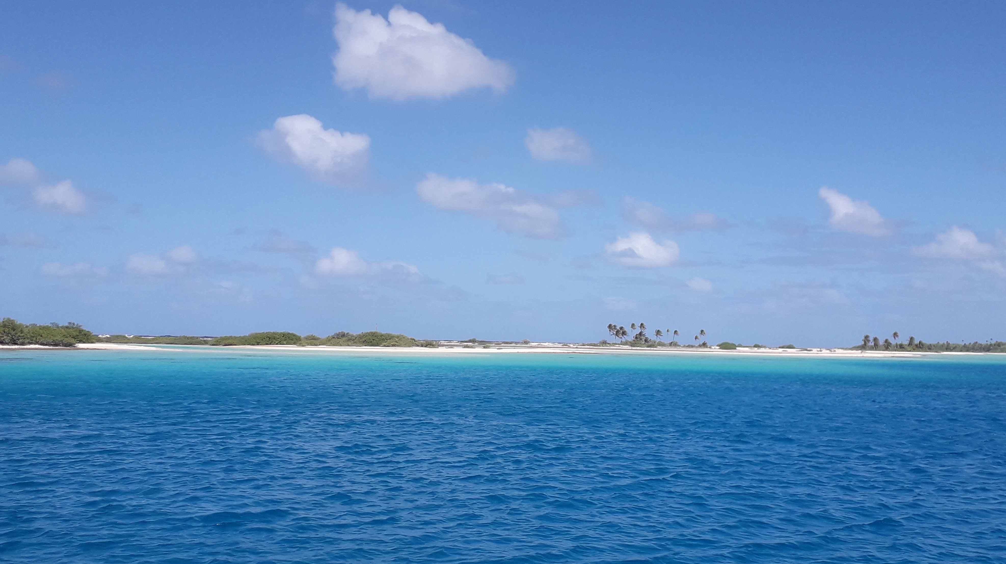
From the volcanic island of Fatu Hiva in the Marquesas to the coral atoll of Raroia in the Tuamotus is only about four hundred miles heading a bit west of south through the South Pacific. Between the two is nothing but deep blue ocean, flying fish and – directly in the way – the low lieing, dangerous, coral atolls of the Isles of Disappointment.
Ideally you need good trade winds from the East to sail south but light weather to enter the atoll. You definitely need to be sure you are securely anchored in a lagoon before the next period of strong south winds. Amazingly the weather looked perfect one day, with five days until the next storm would seal our way, so we drank a coffee with the neighbours from Bengt, lifted anchor and sailed south.
At sea in the Pacific
The first day there was a little too much wind so we made great progress but bounced around on the three meter swell. With the main reefed right down and the small jib, we managed 130 miles. The second day was a little less boisterous but we still achieved over 120 miles.
Our plan was to keep well away from the coral atolls especially as we had read that the charts are wrong and the islands are not where they should be. But! The sun was shining, the sea was calmer and we had a few more hours of daylight so we changed course to sail past the larger atoll of Napuka. The islands are very low and difficult to see over the waves but nearly eight miles out Heidi sighted the palm trees and the radar confirmed that the size and shape were correct. Using satellite photos and lots of eyeball, we sailed past the reef, the church and the airstrip. We saw a few people on shore but we were too far off to wave. And the charts were definitely wrong!
The chart is definitely wrong!
The next challenge was to calculate when to arrive at the tiny passage through the reef that would allow us access in to the lagoon at Raroia. The pilot books suggest that with a wind from the East you should enter just after high tide or just before low tide but that an entry against the ebb is difficult after lots of rain, days of high swell or strong winds. There are no tide tables for Raroia so you have to extrapolate between those for the atolls of Hao and Rangiroa based on their longitudes. We had two sets of tide data on board and they disagreed massively. We sent a message to our weather router and he sent us a third time! Did I mention that there are two different time zones in the islands so you have to adjust for them as well? After a few tries I was pretty certain high tide was going to be at 2000 UTC so 1000 Tuamotos time or maybe low tide was going to be at 1130 Marquesas time – depending on which tables were correct. And all assuming it didn’t rain 🙂
Fifty miles before our destination, and against all weather predictions the wind died. We managed to drift 24 miles in the right direction and “surfed” eight miles along the front of a massive squall. Using the radar to stay just outside the rain we used the squall induced wind for two hours of midnight adventure. Finally our calculations showed that we were going to miss the tide at the passage so we started the engine.
We reached the entrance through the reef just before low tide and could see an out flowing current but, as the guides warn that sometimes the current remains out flowing for days, we headed in. On full throttle we can make 5.2 knots but we averaged 0.4 through the pass. Fifty minutes of trying to stay in the narrow corridor between the steep coral walls while inching forwards against the current was “interesting”.
Finally we entered the lagoon and “only” had to navigate the seven miles to the East side. The lagoon is strewn with coral towers that you definitely do not want to hit. We had identified these using charts and satellite images and then plotted a “hopefully safe” route. Heidi still spent the two hours on the bow identifying coral ahead and one coral tower was only avoided at the last minute as Heidi commanded “Hard to port – now!” To add to the fun there is a pearl farm and they have spread ropes and buoys around like a huge spiders web. Heidi added underwater rope identification to her list of tasks.
Finally, behind the shelter of the palm covered reef, we dropped anchor. An inspection of the surroundings with snorkel mask found coral next to the anchor and a shark swimming under the boat. The shark was OK but the coral meant re-anchoring and another swim.
We set the anchor, attached floats to the chain to keep it off the coral and drank a coffee. The forecast strong winds arrived earlier than expected but found us safely hidden in the middle of nowhere.
Long ago Makemo was headquarters for the french atomic weapon tests in the Pacific and the concrete buildings from then are still standing. Nowadays Makemo Atoll is a quiet backwater, a tiny coral dot in the middle of the Pacific.
We entered the atoll through the passage in the reef and anchored off the village. First stop was, of course, the bakery to buy our baguettes. Everything else we planned on buying was “sold out” until a few days later when a supply ship arrived.
Anchored just off the reef
We arrived just in time for Bastille Day so there was a week of sport and dancing competitions between the different parts of the village. One day we had five local kids on board from the “blue team” so after that we were official “blue team” fans.
Strangely the anchorage turned out to be a “german nest”. We meet the occasional german boat but seldom more than two in one place. After watching the dancing we were sat in a bar – seventeen sailors and only two who didn’t speak german.
With strong winds forecast, we all moved to the south east corner of the Atoll and anchored in paradise. Clear turquoise water, coral formations under water, coconuts to eat on land and a friendly hermit on the beach. The wind blows continuously which keeps us cool and we make more than enough electricity and fresh water with solar and the wind generator. We have been giving water away to boats with no water maker. Once Heidi managed to connect to the nearest mobile phone mast by hauling a router up the mast, we had everything we needed.
Under Artemis is like an aquarium.
I no longer remember when we arrived, I don’t know how long we have been here and I have no idea when we will leave. At the moment we are enjoying life beyond the end of nowhere.
Ein bisschen mulmig war mir schon als wir uns am Eingang zum Makemo Riff befanden, nachdem wir ja schon schlechte Erfahrungen gemacht hatten. Doch dieses Mal lief alles sehr gut ohne große Gegenströmung konnten wir vor der Ortschaft ankern und diesen erkunden. Als Frankreich hier in der Gegend die Nukleartests durchgeführt hat, war Makemo wohl das Basislager und deshalb gibt es hier sogar eine Kathedrale 😲, einen Leuchtturm und viele große Gebäude. Wir hatten Glück denn am nächsten Tag war Feiertag – zum Gedenken der Sturm der Bastie – und trotzdem war die Bäckerei geöffnet. Die beiden Damen dort sprachen exzellentes Englisch und wir konnten sie alles fragen was wir wissen wollten und mangels unserer französisch Kenntnisse nicht in Erfahrung bringen konnten. Wir fragten ob wir uns hier irgendwo Räder ausleihen können doch die Chefin meinte, wenn wir bis Mittag wieder da sind können wir ihre Dreiräder benützen und das natürlich kostenlos. Wir probierten das natürlich aus und es war schon gewöhnungsbedürftig ohne Bremsen und Gangschaltung aber dafür mit viel zu niedrigen Sattel zu fahren. Wir hatten riesigen Spaß und nach 25 km brachten wir unsere Leihräder gerne zurück. Im Ort gab es gleich eine ganze Festwoche mit verschiedenen Attraktionen 👍. Am Vormittag spielten die drei verschiedenen Ortsteile gegeneinander Volleyball, Basketball und Fußball, wobei das gewinnen nicht im Vordergrund stand, denn wenn ein Spieler eine besonders gute Leistung gebracht hatte, bekam er genauso Beifall von den “Gegnern” wie vom eigenen Team und natürlich den Zuschauern, denn keine Frage dass fast alle Atoll Bewohner anwesend waren. Natürlich waren auch wir Segler fast vollzählig anwesend und die 2. Bürgermeisterin bedankte sich bei uns fürs zuschauen. Beim anschließenden Einkehrschwung, stellten wir erstaunt fest, dass von 17 Seglern gerade mal zwei nicht deutschsprachig waren und dass ist wirklich etwas Besonderes. Am nächsten Tag haben wir unseren 1. Driftschnorchelgang gemacht und es war einfach mega toll. Ich hab von Sybille einen Neoprenanzug bekommen und dann gings los. Du gehst ins Wasser und lässt dich von der Strömung mit treiben, echt genial und überhaupt nicht anstrengend. Dank Neoprenanzügen konnten wir auch lange im Wasser bleiben und ich war so glücklich, dass ich nicht gefroren hab, denn beim letzten Mal wars mir sehr schnell saukalt😨😨. Sybille hat mir gleich noch den Anzug geschenkt und jetzt können wir viel länger schnorcheln 👍👍 Tausend Dank nochmal liebe Sybille 😘😘.
Weil fürs Wochenende ein starker Wind, in diesem Fall der Maramu angesagt war, suchten fast alle Boote die geschützte Bucht im Nordosten des Atolls auf. Hier an diesem Strand ist es wirklich unbeschreiblich schön, türkisblaues, durchsichtiges Wasser, Palmen Strand, Korallen Riffs und und und…. Postkarten Gegend.🏝️🏝️ Sybille und Bo kaiten bei 20 Knoten Wind und wir genießen es ihnen zuzuschauen. Das Boot Stella Maris hat ein BBQ am Strand organisiert und wirklich alle Segler sind gekommen und wir hatten riesigen Spaß am Lagerfeuer und Hubert der Einsiedler, dem dieses herrliche Fleckchen Erde gehört, war auch da und wurde kulinarisch mitversorgt. Vom Nudelsalat über Kuskus, Fleisch, Kuchen, frisch gebackenes Brot sowie Stockbrot, Pizza, Popcorn und vieles mehr gab es zu probieren und mir läuft jetzt noch das Wasser im Mund zusammen 😀😀 wenn ich daran denke. Aufgrund des anhaltenden Windes und der Sonne sind unserer Batterien voll und unser Wassertank ebenfalls und so sind wir in der glücklichen Lage, anderen Seglern die keinen Wassermacher haben, frisches Wasser zu geben. Ein sehr schönes Gefühl helfen zu können und zu wissen, dass kein Diesel verbraucht werden muss. Eric ein Schweizer Segler hat heute Unterricht im Brot backen gegeben; sein Sauerteig Brot ist wirklich der Hammer und jetzt hat er die meisten Boote mit Sauerteig versorgt und dann kann die Produktion beginnen 😃.
Unser 1. Atoll Neill hatte versucht die Tides zu berechnen und wann wir am Eingang sein sollten um am wenigsten Gegenströmung zu haben usw.. Unser Navionic Programm, Wim, Davo (zwei Segelfreunde, die unser Wetter Routing machen) und ein anderes Programm gaben uns drei verschiedenen Zeiten von High- und Lowtide an 🙄🙄🙈🙈, also blieb uns nichts anderes übrig als vor Ort zu entscheiden wann wir reinfahren;
Wir erreichten die Einfahrt um 9.30 Uhr und es sah ganz gut aus, also dann nix wie los. Neill am Tiller und ich war damit beschäftigt die Geschwindigkeit im Auge zu behalten. Die Eingangspassage ist ein Korallen Kanal und wenn du über die Seiten schaust, kannst du Korallen Wände sehen 😲😲 beeindruckend aber auch total beängstigend. Wir benötigten für eine Länge von 0,3 Nautikel Miles 48 Minuten was eine atemberaubende Geschwindigkeit von 0,36 Knoten im Durchschnitt ergibt 😲😲😲Danach waren wir erst mal platt 😒😒 doch wir mussten weiter zu unserem Ankerplatz und durch die Riffs und Korallen Türme. Wir haben die Route anhand von Seekarten und heruntergeladen Satelliten Bildern gemacht und jetzt stand ich am Bug und hielt Ausschau. Gott sei Dank kam die Sonne raus und ich konnte die Riffs rechtzeitig sehen. Nach ca 2/3 der Strecke waren überall Bojen von Perlenfarmen und denen mussten wir ausweichen 😲😲😲 also im Blindflug 🙈 und es war nur einmal a bissl knapp 🤭🤭. Wir waren so happy am Anker zu sein, doch wir wollten auf jeden Fall prüfen ob nicht im Umkreis Korallen Türme sind und so sprangen wir mit Taucherbrille ins Wasser – zum Glück – denn wir fanden wirklich welche 😏😏 also nochmal 😃😃nicht zur Strafe nur zur Übung. Beim zweiten Mal war es dann auch gut, doch auch dieses Mal kontrollierten wir unsere Position und entdeckten dann auch unseren 1. HAI in der Lagune. Die Wettervorhersage prognostiziert für die nächsten fünf Tage starken Wind und somit werden wir uns nicht bewegen 😆😆😆 bzw. unsere Artemis nicht. Wir hoffen dass wir a bissl schnorcheln und die Inselwelt entdecken können, aber im Moment haben wir Windstärken von 20 – 25 Knoten hinterm Riff 😲.
Wir haben jetzt fast drei Monate in den Marquesas verbracht und jetzt werden wir uns in Atollen im glasklares Wasser rumtreiben und schnorcheln und was man da noch so alles machen kann 😃. Am Freitag 3.7. Verabschiedeten wir uns von Wim und Elisabeth in Fatuhiva und los gings zu den Tuamotus, jetzt kommen die Korallenriffe und flache Inseln mit Palmen so wie man – ich muss gestehen, dass ich mir die Südseeinseln genauso vorgestellt habe 🏝️🏝️. In Nuko Hiva hat Neill super Informationen von Stephen bekommen welche Atolls besonders schön sind und bei welchen die Einfahrten zu welcher Tages- und Gezeitenzeit am besten zu passieren sind. Auf unserer “Anfahrt” haben wir gleich mal die Iles du des Appointment – eine Atoll Gruppe – gesehen, wir waren total happy dass wir am Nachmittag vorbei gefahren sind und die Insel Napuka mit ihren paar Häusern und sogar einem Flugplatz genau sehen konnten; witzig war auf jeden Fall dass wir auf unserer Navionic Karte – 🤭die sind hier nicht sehr genau- über das Riff gefahren sind.
Hier mitten im Pazifik neben fünf Häusern also wirklich am Ar… der Welt🙄🙄 fängt plötzlich mein Handy an, Nachrichten zu empfangen und ich sende auch gleich einen Status 😃😃. Liebe Grüße aus dem nirgendwo 😆😆
Zuerst wollten wir ja nach Amanu aber da es nochmal 100 Nautikel Miles weiter gewesen wäre und das Wetterfenster zu klein war, haben wir uns dann für Raroia entschieden und ich bin schon total gespannt auf die Riffs und Korallen Türme, hoffentlich entdecken wir alle 🙈🙈😜 denn es soll gar nicht so einfach sein 🙄🙄
Mit Ua Pou haben wir nun die letzte der bewohnten Inseln der Marquesas besucht.👍 Wie wir schon in Nuku Hiva gehört haben soll hier ein Deutscher leben, der Schokolade macht und alle dafür benötigten Zutaten selbst anbaut. Da waren wir natürlich super neugierig, denn Schokolade ist ein absolutes MUSS auf unserer Artemis. Neill nennt mich manchmal einen “Schokoholik”😜 nicht weil ich ohne nicht leben kann, aber doch sehr nervös werde, wenn keine Schokolade an Bord ist.
Wir fragten im Ankerfeld, wo wir denn Manfred finden können und bekamen als Weg beschreibungen: folgt der einzigen Straße und dann an der Abzweigung rechts und später nochmal rechts und wenn ihr dann die Hunde bellen hört seid ihr da😀😀.
Für den Heimweg gab uns Manfred noch einen ganzen Haufen Früchte mit und schwer bepackt und beeindruckt machten wir uns auf den Rückweg. Wie kommt man hier auf die Idee Schokolade zu machen 🤔🤔🤔 keine Ahnung 🙄🙄🙄 aber Manfreds Kreativität sind keine Grenzen gesetzt 👍👍 und seine Schokolade einfach nur himmlisch 😃😃.
Nach ca. 3 km fanden wir Manfreds Reich und klopften mit einem Kochlöffel auf die Pfanne, denn das ist die Klingel. Ein Trio von Hunden begrüßte uns und Manfred hinterher 😀. Als erstes verewigten wir uns – als Segler auf einem Sonnensegel im Garten – dann zeigte uns Manfred sein Reich. Er erzählte uns, wie er hier gelandet ist und was er in seinem Leben schon alles erlebt und gemacht hat. Natürlich bekamen wir ausgiebig Schokolade zum probieren und uns tat die Wahl weh, bei der Entscheidung welche wir mitnehmen wollen 🙈🙈, denn sie waren einfach genial mmmmm……. 👌👌
Von der Anse Hakatea Bucht aus machten wir uns auf den Weg zum Vaipo Wasserfall. Nachdem uns alle erzählt haben, dass es dort ‘ Nono Land’ sei, preparierten wir uns in langen Hosen, langen Ärmeln, festen Schuhen und das bißchen Haut wo noch rausschaute war in Antimücken Spray gehüllt. Im Dorf wurden wir dann gleich mal um 20 € erleichtert, denn das ist das Eintrittsgeld zum Wasserfall, damit der Weg instand gehalten werden kann und alles gepflegt wird 👍. Wir staunten nicht schlecht als wir eine wirkliche breite Steinstrasse vorfanden, die ca. 500 Jahre alt war, nach einer Furt Überquerung ( ohne Schuhe natürlich, denn uns stand das Wasser bis zu den Knien) wurde der Weg immer schmaler. Über Steine, Wurzeln und kleine Bäche kamen wir zu einer alten, verlassenen Stadt. Wir folgten dem Weg bis er plötzlich aufhörte 🙄😏? Und jetzt?? Ich kam mir vor wie “Indianer Jones” durch den Dschungel, über Bäume und große Felsen… Doch wir fanden keinen Weg 🤔🤔. Wir wussten, dass wir den Bach irgendwann überqueren mussten und unser Garmin war uns auch keine große Hilfe, denn in dem tiefen Tal konnte es kein GPS Signal empfangen🙄. Also dann wieder zurück dorthin wo wir ihn verloren hatten und dann entdeckten wir die “Brücke” ein Baum quer über den Bach 👍 danach fanden wir problemlos zu unserem Ziel. Zum Baden lud uns die braune Brühe nicht gerade ein und so kamen wir gar nicht in Versuchung “Nono Futter” zu werden.
Nach einem ca. 10 km langen Fußmarsch waren wir zurück im Dorf, haben uns mit Früchten versorgt und uns dann auf den Heimweg gemacht. Ein toller Tag und ich bin mir jetzt schon absolut sicher, dass wir morgen unsere Beine spüren werden 😜🙈🙈 aber immerhin haben wir keine Nono Stiche abbekommen 👍👍👍.
Manfred Drechsler fled East Germany in his mother’s arms when he was six months old. As an adult he left Germany for French Polynesia and a new life as a helicopter pilot. Then he moved to the mountains of Ua-Pou and began producing chocolate from home grown cocoa.
The “chocolate man of Ua-Pou” doesn’t advertise. He doesn’t need to as news of his amazing chocolate spreads amongst cruisers like a virus. We heard about him while anchored in Nuku Hiva and set off to search for the chocolate that even swiss cruisers admit “is something special”. Some one pointed out the correct anchorage on our charts and, once on land, a local pointed us up the track and told us to continue until we heard the dogs. The track wound ever upwards through the jungle but finally we reached a garden, rang the gong and were answered by barking dogs.
Manfred works like a drug dealer. He started by giving us free samples during a conversation about his exciting life and only then did he sell us the “stuff”. The chocolate is unbelievably good and has nothing to do with anything you ever buy in a shop. It is an absolute taste sensation. Everything is grown on his farm, water is piped from the mountains and the electricity is made with solar and a water generator. We were impressed.
We left not only with chocolate; Manfred also gave us a whole bag of fresh fruit from his garden and a tip to try pickling some of the green star fruit. It was a heavy load that we carried back to the boat but our fruit shelf now looks amazing. And the chocolate is buried in the fridge for special moments.
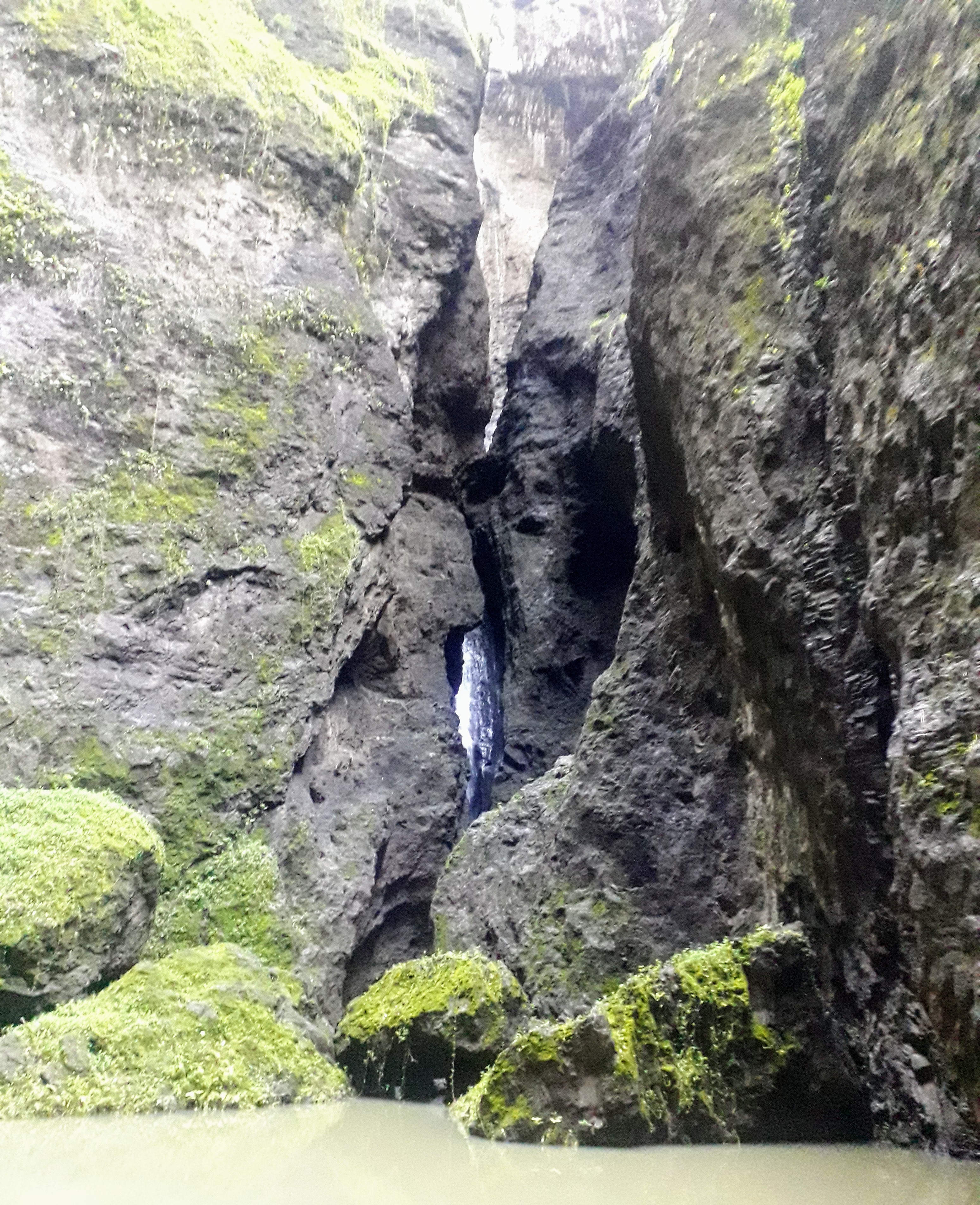
In the Vaipo valley on the island of Nuku Hiva there is a huge waterfall. The valley is only accessible by boat and cut off from the surrounding areas by huge vertical cliffs. Heidi commented that it looks like the land that time forgot.
Having anchored in the bay, we paddled the dinghy to the beach, towed it up the river at low tide and moored it to an overhanging palm tree. We took the main path through the immaculate village of Hakaui and exchanged greetings with all those we met. A fully tattooed local asked how we liked his valley and, when we gave a positive answer, presented us with a grapefruit from his garden.
Once out of the village, we followed the remains of a substantial track some three meters wide. This was raised above the surroundings and lined with large stones. At one point we had to ford the river but, despite stories from other sailors, nothing bit us. As we continued through the jungle we were continually passing ruins and the foundations of houses. At one point we passed an area that looked like the ceremonial areas we knew from elsewhere. The impenetrable jungle was obviously hiding a lost city. Heidi was in Indiana Jones mode, dreaming of lost diamonds and head hunters.
At one point we saw the waterfall across the valley cascading many hundreds of meters down the vertical cliff. Down by the river we lost the path and spent half an hour clambering over moss covered ruins and under huge trees before returning to the river. On our second attempt we realised that the fallen tree was actually the bridge and crossed it to find the path continued on the far side. Up close, the waterfall was less impressive as you could see less of it but the gorge was stunning in its size and steepness.
Back in the village we learned that before the missionaries arrived, “with their god and their diseases”, there had been 20 000 people living in the valley which explained all the ruins. The city had extended from the river up to the temples which was the reason for the “main highway” that we had followed. A local lady proudly explained how her ancestors had lived here before the Europeans decimated the islands.
Another exciting day and further proof that a boat gets you to unbelievable places that you would otherwise never see.